RKTN — DAEGU / Daegu International
RKTN AD 2.1 AERODROME LOCATION INDICATOR AND NAME
RKTN — DAEGU / Daegu International
RKTN AD 2.2 AERODROME GEOGRAPHICAL AND ADMINISTRATIVE DATA
| 1 | ARP coordinates and site at AD |
355338 N 1283932 E 315° / 1 377 m from THR RWY 31L |
| 2 | Direction and distance from city | 4.8 km Northeast of Daegu City Hall |
| 3 | Elevation/Reference temperature | 120 ft / 31 °C (AUG) |
| 4 | Geoid undulation at AD ELEV PSN | 93 ft |
| 5 | MAG VAR/Annual change | 7 °W (2005) |
| 6 | AD Administration, Address, Telephone, Fax, AFS |
Post:
Daegu Airport Office
Post:
400-1, Jijeo-dong, Dong-gu,
Tel: 82-53-980-5203, 5204 Fax: 82-53-982-4154 AFS: RKTNZPZX |
| 7 | Types of traffic permitted (IFR/VFR) | IFR/VFR |
| 8 | Remarks | Military Air Base |
RKTN AD 2.3 Operational hours
| 1 | AD | H24 |
| 2 | Customs and Immigration | HS |
| 3 | Health and sanitation | HS |
| 4 | AIS Briefing Office | HS |
| 5 | ATS Reporting Office | HS |
| 6 | MET Briefing Office | H24 (manned for 2100-1300 UTC) |
| 7 | ATS | H24 |
| 8 | Fuelling | HS |
| 9 | Handling | HS |
| 10 | Security | HS |
| 11 | De-icing | HS |
| 12 | Remarks |
Base Quiet Hour : 1300-2100 UTC daily
During the Quiet HR, unsurpassed ENG runs and nonessential ACFT OPS are prohibited, except civil airlines authorized by ROKAF |
RKTN AD 2.4 Handling services and facilities
| 1 | Cargo-handling facilities | Up to 46 tones handling possible |
| 2 | Fuel/oil types | JET-A1 |
| 3 | Fuelling facilities/capacity |
Elevated storage tank 3 unit/total 900 000 Liters, 3
fuel tanks with 300 000 Liters. Refueling available by trucks. |
| 4 | De-icing facilities |
One de-icing pad.
See Aircraft Parking/Docking Chart. |
| 5 | Hangar space for visiting aircraft | NIL |
| 6 | Repair facilities for visiting aircraft | NIL |
| 7 | Remarks | NIL |
RKTN AD 2.5 PASSENGER FACILITIES
| 1 | Hotels | 1, At AD(51 rooms available), and in the city |
| 2 | Restaurants |
3 Restaurants in passenger terminal (1 Korean food, 1 western food, 1 other) |
| 3 | Transportation | Buses, Taxies, and rental cars from AD |
| 4 | Medical Facilities | PATIMA Hospital near the AD (about 2.1 Km). |
| 5 | Bank and Post Office | Bank available at AD |
| 6 | Tourist Office | Available at AD |
| 7 | Remarks | http://www.airport.co.kr/mbs/daegu/ |
RKTN AD 2.6 RESCUE AND FIRE FIGHTING SERVICES
| 1 | AD Category for fire fighting | Category 7 |
| 2 | Rescue equipment |
|
| 3 | Capability for removal of disabled aircraft |
Specialized aircraft recovery equipment available for
up to
A300-600 size aircraft. 1 & 3 pole recovery
jacks, 220 ton
mobile crane including other
accessory equipment can be provided
by airlines
and agencies.
Korea airports Corporation is the coordinator for the removal of disabled aircraft and can be reached at Airport Duty Manager. (Tel: 82-53-980-5331) |
| 4 | Remarks |
* ROKAF : Republic of Korea Air Force
** AFFF : Aqueous Film Forming Foam *** KAC : Korea Airport Corporation |
RKTN AD 2.7 SEASONAL AVAILABILITY CLEARING
| 1 | Type of clearing equipment |
|
| 2 | Clearance priorities |
|
| 3 | Remarks |
Snow clearance information promulgated by SNOWTAM.
* ROKAF : Republic of Korea Air Force ** KAC : Korea Airports Corporation |
RKTN AD 2.8 APRONS, TAXIWAYS AND CHECK LOCATIONS DATA
| 1 | Designation, Apron surface and strength |
a. Surface : Concrete b. Strength - North Apron(Stand 1,2,3) : PCN 55/R/B/W/T - South Apron(Stand 4,5,6) : PCN 49/R/B/W/T (See Aircraft Parking/Docking Chart) |
| 2 | Designation, Taxiway width, surface and strength |
a. Width : 23M
b. Surface : Concrete c. Strength : PCN 46/R/B/W/T (TWY 8) |
| 3 | Altimeter checkpoint location and elevation |
a. Location : APRONS
b. Elevation : 32M |
| 4 | VOR checkpoints | VOR : NIL |
| 5 | INS checkpoints | INS: See Parking/Docking Chart |
| 6 | Remarks | NIL |
RKTN AD 2.9 SURFACE MOVEMENT GUIDANCE AND CONTROL SYSTEM AND MARKING
| 1 | Use of aircraft stand ID signs, TWY guide lines and visual docking/parking guidance system of aircraft stands |
|
| 2 | RWY and TWY markings and LGT |
|
| 3 | Stop bars | NIL |
| 4 | Remarks | NIL |
RKTN AD 2.10 AERODROME OBSTACLES
| In approach/TKOF areas | In circling area and at AD | Remarks | |||
|---|---|---|---|---|---|
| 1 | 2 | 3 | |||
|
RWY NR/Area
affected |
Obstacle type
Elevation Marking/LGT | Coordinates |
Obstacle type
Elevation Markings/LGT | Coordinates | |
| a | b | c | a | b | |
|
31L/APCH
13R/TKOF |
Mountain
2539FT NIL |
354931.9N
1290137.6E |
Hill
280FT NIL |
355439.1N
1283741.5E |
|
|
31R/APCH
13L TKOF |
Mountain
2231FT NIL |
354655.5N
1285646.2E |
Hill
430FT NIL |
355248.6N
1284146.7E | |
|
Mountain
2104FT NIL |
354418.6N
1284937.5E |
Hill
561FT NIL |
355153.4N
1283941.0E | ||
|
Hill
430FT NIL |
355248.6N
1284146.7E | ||||
|
Hill
907FT NIL |
355605.8N
1283657.1E | ||||
|
Building
266FT NIL |
1.5NM from
RWY 31L THR | ||||
|
13L/APCH
31R/TKOF |
Hill
280FT NIL |
355439.1N
1283741.5E | |||
|
13R/APCH
31L/TKOF |
Hill
915FT NIL |
355606.0N
1283656.0E | |||
RKTN AD 2.11 METEOROLOGICAL INFORMATION PROVIDED
| 1 | Associated MET Office |
Daegu Airport Weather Office
(Tel : 82-53-983-0365, Fax : 82-53-985-0366) |
| 2 |
Hours of service MET
Office outside hours |
0600 to 2200 KST (2100 to 1300 UTC) Korea Aviation Meterological Agency at RKSI |
| 3 |
Office responsible for TAF preparation
Periods of validity |
ROKAF MET Office
30 hours at 0000, 0600, 1200, 1800 UTC |
| 4 |
Trend forecast
Interval of issuance |
Trend Type forecast
1 hour(METAR) and when SPECI reported for 2100-1300 UTC |
| 5 | Briefing/consultation provided |
Manned available for 2100-1300 UTC, if required
Self available for 24 hours |
| 6 | Flight documentation Language(s) used | Aerodrome forecasts(TAF code form), SIGWX charts, WINTEM charts, SIGMET information in English |
| 7 | Charts and other information available for briefing or consultation | Analysis charts(surface and upper air), Prognostic charts, Graphic displays and other model outputs |
| 8 | Supplementary equipment available for providing information | Satellite and Doppler weather radars imageries |
| 9 | ATS units provided with information | FIC and TWR |
| 10 |
Additional informaton
(limitation of service, etc.) | Automated METAR is provided during operational hours of the aerodrome as well as all observation data, model outputs and forecasts produced by KMA and WAFS are available at the Office through Internet link |
RKTN AD 2.12 RUNWAY PHYSICAL CHARACTERISTICS
|
Designations
RWY NR |
TRUE
BRG |
Dimension of
RWY(M) |
Strength(PCN)
and surface of RWY and SWY |
THR coordinates
RWY end coordinates THR geoid undulation |
THR elevation and
highest elevation of TDZ of precision APP RWY |
|---|---|---|---|---|---|
| 1 | 2 | 3 | 4 | 5 | 6 |
| 13R | 124.23 ° | 2755 × 45 |
66/R/C/X/T
Concrete |
355402.19 N
1283845.06 E | THR 33 m / 110 ft |
| 31L | 304.23 ° |
355311.90N
1284015.90E |
THR 35.9 m /
117.8 ft
TDZ 35.9 m / 117.8 ft | ||
| 13L | 124.23 ° | 2743 × 45 |
77/R/C/X/T
Concrete |
355405.37 N
1283848.35 E | THR 34 m / 112 ft |
| 31R | 304.23 ° |
355315.30 N
1284018.82 E |
THR 36.6 m /
120.1 ft
TDZ36.7 m / 120.3 ft | ||
| 7. Slope of RWY-SWY | |||||
a. RWY 31L/13R
 b. RWY 31R/13L 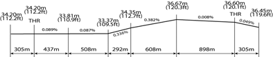 | |||||
|
SWY
dimensions(M) |
CWY
dimensions(M) |
Strip
dimensions(M) | OFZ | Remarks | |
|---|---|---|---|---|---|
| 8 | 9 | 10 | 11 | 12 | |
| - | - | 2 875 × 248 | - |
· The surface of RWY 13R/31L
and 13L/31R are grooved.
(Except 300 m
inward from each
THR RWY 13L/31R)
·The width of strip does not meet criteria in Annex 14) | |
| - | - | 2 875 × 248 | - | ||
| - | - | 2 863 × 200 | - | ||
| - | - | 2 863 × 200 | - | ||
RKTN AD 2.13 DECLARED DISTANCE
| RWY Designator |
TORA
(M) |
TODA
(M) |
ASDA
(M) |
LDA
(M) | Remarks |
|---|---|---|---|---|---|
| 1 | 2 | 3 | 4 | 5 | 6 |
| 13R | 2 755 | 2 755 | 2 755 | - | |
| 13L | 2 755 | 2 755 | 2 755 | 2 755 | - |
| 13L | 2 743 | 2 743 | 2 743 | 2 743 | - |
| 31R | 2 743 | 2 743 | 2 743 | 2 743 | - |
RKTN AD 2.14 APPROACH AND RUNWAY LIGHTING
| RWY |
APCH
LGT type LEN INTST |
THR
LGT Color WBAR |
VASIS
(MEHT) PAPI |
TDZ
LGT LEN |
RWY Center
line LGT LEN Spacing Colour INTST |
RWY edge LGT
LEN Spacing Colour INTST |
RWY
End LGT Color WBAR |
SWY
LGT LEN Color |
|---|---|---|---|---|---|---|---|---|
| 1 | 2 | 3 | 4 | 5 | 6 | 7 | 8 | 9 |
| 13R |
SSALF
420 m LIH |
Green Green |
PAPI
Both/3.3° (52.8 ft) | NIL |
2755 m
30 m White |
2755 m
60 m White LIH |
Red
Red | NIL |
| 31L |
ALSF-1
900 m LIH |
Green
Green |
PAPI
Both/3.0° (54.7 ft) | 900 m |
2755 m
30 m White |
2755 m
60 m White LIH |
Red
Red | NIL |
| 13L |
SSALR 420 m LIH |
Green
Green |
PAPI
Both/3.0° (58.4 ft) | NIL | NIL |
2743 m
60 m White LIH |
Red
Red | NIL |
| 31R |
ALSF-1
750 m LIH |
Green
Green |
PAPI
Both/3.0˚ (56.1 ft) | NIL | NIL |
2743 m
60 m White LIH |
Red
Red | NIL |
|
10. Remarks:
Circling guidance lights are installed as follows :
| ||||||||
RKTN AD 2.15 OTHER LIGHTINGS, SECONDARY POWER SUPPLY
| 1 | ABN/IBN location, characteristics and hours of operation |
At hangar near the old TWR FLG W/G EV 10 SEC
/IBN : NIL H24 |
| 2 |
LDI location and LGT
Anemometer location and LGT | NIL |
| 3 | TWY edge and center line lighting |
Edge: All TWY
Center line : TWY 7(BTN W2 and W3) |
| 4 | Secondary power supply/swithch-over time |
Secondary power supply to all lighting at AD.
Switch-over time : 15 SEC |
| 5 | Remarks | NIL |
RKTN AD 2.16 HELICOPTER LANDING AREA
| 1 | Coordinates TLOF or THR of FATO | - |
| 2 | TLOF and/or FATO elevation | - |
| 3 | TLOF and FATO area dimensions, surface, strength, marking | - |
| 4 | True and MAG BRG of FATO | - |
| 5 | Declared distance available | - |
| 6 | APP and FATO lightng | - |
| 7 | Remarks | As directed by ATC |
RKTN AD 2.17 ATS AIRSPACE
| 1 | Designation and lateral limit |
Daegu CTR,
A circle, radius 5 NM centered at 355328.58 N 1283924.84 E and containing corridor with 5NM width extended to 7.8NM from RWY 31L |
| 2 | Vertical limits | SFC to 4000 ft AGL |
| 3 | Airspace classification | C |
| 4 |
ATS unit call sign
Language(s) |
Daegu Tower
English / Korean |
| 5 | Transition altitude | 14000 ft MSL |
| 6 | Operational Hours | H24 |
| 7 | Remarks | NIL |
RKTN AD 2.18 ATS COMMUNICATION FACILITIES
|
Service
designation | Call sign | Frequency |
Hours of
operation | Remarks |
|---|---|---|---|---|
| 1 | 2 | 3 | 4 | 5 |
| APP | Daegu Approach |
135.9 Mhz
346.3 Mhz | H24 | NIL |
| DEP | Daegu Departure |
120.25 Mhz
135.9 Mhz 230.3 Mhz | H24 | NIL |
| TWR | Daegu Tower |
126.2 Mhz
236.6 Mhz 365.0 Mhz | H24 | NIL |
| GND | Daegu Ground |
118.2 Mhz
275.8 Mhz | H24 | NIL |
| ATIS | Daegu Airport |
127.65 Mhz
240.6 Mhz | 2100 - 1300 UTC | Digital ATIS service available |
| EMERG |
121.5 Mhz
243.0 Mhz | H24 | NIL | |
|
Scheduled Inspection Time :
- DEP(120.25 Mhz), GND(118.2 Mhz) and ATIS : Every 3rd THU(1300-2100 UTC) of the month | ||||
RKTN AD 2.19 RADIO NAVIGATION AND LANDING AIDS
|
Type of aid,
CAT of ILS/MLS | ID | Frequency |
Hours of
operation |
Position of
transmitting antenna coordinates |
Elevation
of DME transmitting antenna | Remarks |
|---|---|---|---|---|---|---|
| 1 | 2 | 3 | 4 | 5 | 6 | 7 |
|
LOC
ILS CAT I | ITAG | 108.7 Mhz | H24 |
355408.12 N
1283834.32 E | ||
| DME | (CH24 ) | H24 |
355406.36 N
1283833.04 E | |||
| GP | 330.5 Mhz | H24 |
355315.31 N
1284002.90 E | 3° ILS RDH 52 ft | ||
| VOR/DME | DOC |
116.5 Mhz
(CH 112 ) | H24 |
355413.58 N
1283828.95 E | 30 m |
VOR unserviceable
RDL 000-040 beyond 10NM BLW 10 000 ft RDL 040-070 beyond 10NM BLW 8 500 ft RDL 070-100 beyond 10NM BLW 10 000 ft RDL 335-360 beyond 16NM BLW 7 000 ft DME unserviceable RDL 000-110 beyond 13NM BLW 13 000 ft RDL 160-230 beyond 20NM BLW 8 000 ft RDL 320-360 beyond 17NM BLW 8 500 ft Scheduled Inspection time : Every 3rd THU(1300-2100UTC) of the month. |
| VORTAC | TGU | 112.2 Mhz | H24 |
354835 N
1283527 E |
VOR/TACAN unserviceable
RDL 155-CW-185 beyond 33NM BLW 9 000 ft RDL 208-CW-225 beyond 26NM BLW 7 000 ft VOR unserviceable RDL 084 BTN 5DME and 17DME BLW 15 000 ft BTN 18DME and 22DME BLW 25 000 ft RDL 253 BTN 7DME and 23DME BLW 15 000 ft BTN 24DME and 30DME BLW 25 000 ft RDL 282 BTN 8DME and 15DME BLW 15 000 ft BTN 16DME and 32DME BLW 25 000 ft RDL 324 BTN 9DME and 18DME BLW 15 000 ft BTN 19DME and 26DME BLW 27 000 ft Scheduled Inspection time : Every 3rd WED(1500-2000UTC) of the month | |
|
LOC
ILS CAT I | IDAG | 111.9 Mhz | H24 |
355411.64 N
1283837.03 E |
Scheduled Inspection time :
Every 1st THU(1300-2100UTC)of the month | |
| DME | (CH56 ) | H24 |
355413.75 N
1283838.66 E | 〃 | ||
|
Scheduled Inspection Time :
- ILS/DME(ITAG) : Every 1st THU(1300-2100 UTC) of the month | ||||||
RKTN AD 2.20 LOCAL AERODROME REGULATIONS
1. Restrictions
2. Helicopter OperationsAll VFR helicopter traffic shall be maintained at or below 600 ft within CTR, unless otherwise cleared by ATC. |
RKTN AD 2.21 NOISE ABATEMENT PROCEDURES
| NIL |
RKTN AD 2.22 FLIGHT PROCEDURES
1. IFR Procedures1.1 Refer to Instrument Approach and Departure Charts1.2 Circling Approach
1.3 Take-off Minimum (for all aircraft)
a. RWY 31L b. RWY 13R
a. RWY 31R b. RWY 13L
2. Procedures for VFR flights within Deagu TMA
3. RADAR Procedures
3.1 PAR Approach
3.2 ASR Approach
4 RADIO COMMUNICATION FAILURE PROCEDURE
4.2 VFR
| |||||||||||||||||||||||||||||||||||||||||||||||||||||||||||||||||||||||||||||||||||||||||||||||||||||||||||||||||||||||||||||||||||||||||||||||||||||||||||||||||||||||||||||||||||||||||||||||||||||||||||||||||||||||||||||||||||||||||||||||||||||||||||||||||||
RKTN AD 2.23 ADDITIONAL INFORMATION
|
